Sunday, September 30, 2007

New Tool Kit

If you can't GO riding, you might as well do something to look forward to riding again. This weekend was just positively crummy. It actually snowed a bit yesterday, in addition to all the raining it did. Total crap before October, if you ask me.

So, I opted instead to get some upgrades ready for the bike. One of them being this nifty PVC toolkit that I'll store on my skid plate. (Once I get my skid plate.) I got the idea from a riding forum somewhere, I can't recall where. The concept is pretty simple, though. I did go a bit different route, though. Most I've seen just use normal end caps, or a screw-type end cap. I found (at Lowe's) these temporary caps. I'm not sure what they're actually called, but they're really great. I used a 3 inch PVC tube. Including caps, the thing is about 10 3/4 inches wide. (~273mm.) The tube is about 1/4 inch think (6mm). I don't really worry about breaking it.

The Tool Kit

Nifty End Cap
I really love this thing. They basically just squeeze the seal between two pieces of plastic to push it out to press against the pipe. They work beautifully. My only concern is getting the wingnut busted off in a crash, but I could always add a normal nut at that point.

In Place
This is another shot of the cap in place on the tube. Like I said, I'm not sure how crashable they are, but they seem extremely sturdy and I'm not really worried. They seem as water tight and secure as a normal cap, plus (I think) they are easier to get off the tube. Did I mention they were actually CHEAPER than a normal threaded cap & adapter? Go figure... Oh, and yes that wingnut is freaking huge. 2.46" (62.8mm) from tip to tip. You won't have any trouble torquing this down with your fingers.

Thursday, September 27, 2007

Well it's official...

Blogspot simply does not like to have multiple images in one post. You can only upload five at a time, and it always inserts them above the ones you've previously uploaded. So, getting a layout that follows a timeline is a giant pain in the butt. For example, today's ride is ALLLLL marfed up on the blog, but looks fine in the preview window when I created it. I don't know. I'm going to have to look into getting a different place to put my ride blog. Either that or I'm going to have to figure out a different way of handling pictures. I'll keep you posted.

High Uintas

GPX File
Google Earth

Blogspot apparently, doesn't like my actual content, so you'll have to scroll down to see it. Stupid WYSIWYG editors. It even PREVIEWS right!! Oh well...


This is the same clearing, from a different angle. From here, I'm kinda shooting back towards the way that I came. There were several people camping in this area, it looks like a good place TO be camping. I'm guessing that if the weather is nice, you'll usually find people here.
I almost missed the spot where the road splits and heads away to Strawberry Peak. (If you've got the GPS file, it's the waypoint marked as "Oops.") The road (trail) to Strawberry Peak was pretty darned rocky. There were a couple big mudholes, as well. It's definitely better suited to a four-wheeler than a motorcycle. I thought I'd dump it more than once in either the mud or the rocks.
After clearing all the muck and rocks, and once I got close to the summit, it broke out of the trees into just beautiful views of all the surrounding areas. Here, Strawberry Reservoir is visible in the distance. The area was some of the most beautiful I've ridden through. Turned out to be some of the most treacherous as well.
This is looking back through what I just rode up to get to the previous picture's location. Doesn't look too bad, does it? This spot wasn't. Hardpack, and only a few rocks. Prior to this location was pretty bad, though.
Sheep! This is RIGHT beneath the summit of Strawberry Peak. I was more than a little surprised to see sheep way up here, but they apparently weren't surprised to see me. They kept their eyes on me, but didn't show any signs of getting agitated and wanting to run off. They probably see a lot of ATVs come through this area during hunting season.
Looking north-ish past the sheep into one of the beautiful vistas beyond. I was pretty darn pleased with myself for choosing this area to go riding in.
Now, this part of the trail was quite nice. But above and below this was pure hell. If you're following along with the GPS file, there's a way point marked "OMG!" And yeah, the portion of the trail between Strawberry Peak and the waypoint marked as "Junction" is just awful. Nothing but softball-sized rocks (and bigger) and the trail is positively packed with them. I ended up sliding sideways down the trail more than once as I struggled to keep the wheels below me. I don't think I'll probably ever take this route again.
The trees were gorgeous. Green, yellow, red, orange... You name it, I pretty much saw it.
This is actually taken some point past the Junction waypoint. I had initially planned on going south at the Junction (a route I've been on before) but I still had plenty of daylight so opted to follow a trail that I had laid out for a future ride. This was taken out east of the Junction waypoint. Not sure how far... I actually did end up taking the entire extra route that I was going to use later. Took less time than I thought it would.
This is still somewhere between the "Junction" waypoint and the "WTF" waypoint. Not sure where. I need to get a GPS that can plug into my camera and automatically load the lat/long into the picture.
THIS was actually taken past the "WTF" waypoint. What was the WTF? Well, at the point I hit the WTF waypoint, there was a sign saying no off-road vehicles. I figured that since my bike is also street legal, that wouldn't be a problem. So yeah, I just kept on truckin. I did see a HUGE elk. He ran parallel with me about 15 yards away before crossing in front of me and running off. Had at least 7 points on each side. Some hunter sure missed his chance. I'm glad I saw the elk and a hunter didn't. Anyway, I belive this is Hobble Creek, and it runs very close to the road.
The sides of the ride were just littered with campsites like this one. It'd be a great place to go out camping some time. Not during hunting season, though.
MORE TREES! This was taken from the same spot as the campsite pic above.
The cows and their corral. No cows in it, but there are a LOT of cows on the road between the WTF waypoint and the end of the ride. Be on your guard. Also, watch out for trucks barrelling down the road around the corners.
The road ahead. At this point I was nearly out of the canyon. The road was (obviously) paved, and it was nice to make up some time as the sun was going down. I still made it back to Orem with a bit of daylight left. I definitely pushed my luck, though.
This was really a stellar ride. One of the most beautiful I've been on, and certainly one of the scariest. I really don't think I could be convinced to come down this side of Strawberry Peak again. At least not without a lighter bike and much better tires. It's a miracle I never dropped the bike as it is. I cam mightly close more than once. If you've got excess testosterone you need to burn off, though, this might be a good ride for you. Make sure you bring your camera and a full complement of your protective gear. You just might need both.

Tuesday, September 25, 2007

An excellent romp.

After looking around for a while on Google Earth, I finally decided on riding around the area past Wallsburg, Utah. It just felt like the place to be. And it was. If all rides were this good, I probably wouldn't have a job. Or a motorcycle. I guess it's a good thing all rides aren't this good.

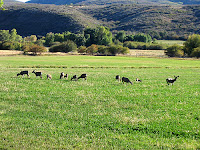
The animals in this pic are... 4 legged. I don't know what they are, because I'm not much of a sportsman. They were right there in the middle of Wallsburg, though, and didn't really seemed to concerned about what was going on. They did keep their eye on me, though.

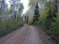
Most of the trees on this circuitous route are aspen or various flavors of pine. Again, it's a great time of year to be out riding in the Uintas, the changing colors are quite a sight. This trip was no exception. Some of the canopies formed by the trees over the road was quite breathtaking. But, I didn't stop and take nearly enough pictures. When I ride this late in the day, I kinda feel an urgency to get where I'm going. I don't want to be out on unfamiliar trails after dark.

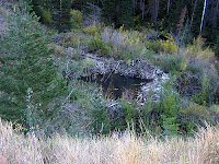
Now, it's been a while since I've seen one, but I'd swear this is a beaver dam. We had a few of these periodically on the Little Colorado River in Arizona growing up. The beavers were mostly a nuisance, damaging the few trees that grew along the banks in the high desert where we lived. Up here in the mountains, though, I'm guessing there's ample wood to keep beavers busy for a very long time.

At the mouth of the canyon at Wallsburg, there's a sign warning that the road is impassible due to snow & other treacheries. There's no snow yet, but the road was a bit rough in spots. For the most part, though, it was pretty nice. It's not really scenery you just want to blow through, though. My average speed through the mountains was only 16mph. Take it easy. That's what you're out here for, isn't it?

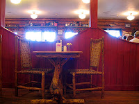
If you're following with GPS software, you'll see "Good Eats" as a waypoint. This is at Daniel's Pass, where some small-town folk will make you feel right at home.

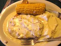
There's not much AT Daniel's Pass. A general store, cafe, and hotel are about all you'll find. Still, the service is great, the people are friendly, the food is terrific. Oh, and the soup is hot. You've been warned.

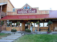
It's a perfect little rustic getaway. My first experience with this place was after riding a portion of the "Adventure Highway" east of Heber, Utah. The lady I talked to at the time indicated that she'd been there for some time. And, she liked being there because she felt like good service and a friendly face to talk to were two important things in life. She made an impression on me with her sincerity, and I make it a point to stop by Daniel's Summit every time I'm out there. In today's case, I even made it a point to end up there after I had finshed tromping through the mountains.

It's not as out-of-the-way as some would like, but it's definitely small, and you'll get that feeling as you take in the area. If you're in the area, it's well worth the time to stop by and say "howdy." It's also convenient in that Daniel's Summit is central to a good many mountain trails, only one of which I had time to explore today. This can be your "base camp" as you go tromping off through the wilderness. (Treading lightly, of course.)

All-in-all, an outstanding short ride. Full round trip from the Provo/Orem area is only about 2 hours, I'd guess. If you take the time to really run around and explore the different trails, I'm sure you could spend a lot more time up here than that. Beautiful area, though. It's making me seriously consider coming up here for my next day-trip. There would definitely be worse places to go.

GPX File
Google Earth

Monday, September 24, 2007

Wooo!

Decided it would be fun to post ride logs of my rides, even the short, dumb ones. These posts made possible by my new Garmin 60Cx GPS. It rules. I highly recommend it, as well as Topo 2008. Normally I'd throw in a rant right now about how stupid it is for GPS makers to not include real maps with their GPS receivers. BUT, that's not what this blog's for... I have other blogs to piss and moan on.

Ended up picking up some supplies today. Snagged a Fox chest protector, Shift waterproof/insulated gloves, and a Klim Wind Stopper balaclava. Gotta love products made by Gore. Also have a pair of Shift Assault pants on order. Hopefully they'll get here before too long.
But, I decided that I needed to try out my new stuff this afternoon. Well, "try out" is used loosely. I hope I don't ever really need to "try out" my safety gear.

So, today took me up the Squaw Peak road. I've ridden this dirt road between Provo Canyon and Hobble Creek Canyon a good few times now. It's good for a short, few hour jaunt.

Didn't get any pics (my bad) but the trip was beautiful. The trees are changing, so it was very colorful. The air smelled just great after the rain/snow that fell over the weekend. Most of the snow had melted at altitude, but there were still some patches that the sun had missed. The air was fresh and smelled great.

Parts of the road were a little precarious. The melting snow had left some extremely slick mud spots, I thought I was going to turf a couple times on them. Definitely need to get better tires. That'll have to wait. I find it tough to replace perfectly good rubber anyway. Even if the rubber is awful. Still have at least 1000 on the factory rides. Probably longer. We'll see how the finances hold out.

When I left for the ride, it was around ~55 degrees or so at "ground" level. It did get much colder as I went up into the snow level. One of these days I'll have to take a thermometer and see how much difference there is. Fortunately, my new gloves kept me (mostly) comfortable. It'll be nice once I get some grip heaters installed. My legs did get pretty cold where the wind was hitting them. It's thermal time, if you're riding high.

I didn't double check that my GPS was recording my track until about halfway through the ride. It wasn't! So, all I'll have to post for today is the second half. It's not really hard to get to the path though, it's a pretty common area. Still, great fun.

GPX File
Google Earth Version